SA Site Cover: Pen Dinas Hill Fort, Aberystwyth by Lyn Pease
 |
| Pen Dinas Hill Fort, Aberystwyth |
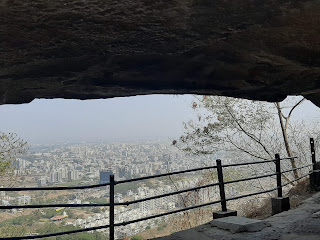
Pen Dinas is the pre-eminent hillfort on the Cardigan Bay coast. The position of Pen Dinas allowed for visual command and political control of the two regional arterial rivers, with sweeping views both inland and also to the North and South of Cardigan Bay. This hour-glass shaped fort is situated on a ridge between the rivers Rheidol and Ystwyth. Two peaks are enclosed and it is clear that originally they were separate enclosures.
At first the northern summit was surrounded by ramparts with a timber revetment and a ditch. Soon afterwards, the southern crest was more substantially fortified with a stone-faced rubble bank and ditch some 3m deep. There were entrances at the north and south with gates supported by posts. A period of decay or deliberate destruction may have followed before the southern fort was re-modelled.
 Eventually both forts were joined together with a new revetted wall across the saddle between the peaks, known as the Isthmus, and around the northern fort. An entrance to the enlarged enclosure with a four-post gateway was constructed midway along the east side. This final stage dates from the first century BC. A number of round buildings have been traced, though the interior of both forts have been damaged by ploughing. When complete the hill fort would have been awe-inspiring as no other buildings in the region stood as tall as Pen Dinas.
  However, the local shale did not make robust building material and there is evidence for buttresses and props at the foot of some walls and gateways which suggests that the structures were constantly at risk from bulging and collapse. Timber used for the gateways would also have rotted eventually. The finished form of the hill fort suggests that the enclosed Isthmus could have been used as a controlled public space for fairs or markets, reinforcing the role of the hill fort as an economic power in the region. The main forts both south and north would have been protected from the visitors by the large gates at their entrances.
The Hill Fort was excavated by the Archaeology Department at Aberystwyth University between 1933 and 1937 but their findings were not published until 1963. The excavations revealed well-built prehistoric dry-stone walls and gateway passages. Finds included glass and stone beads, spindle whorls and loom weights (evidence of weaving) and a cache of over 100 slingshots. All of these finds have been sadly lost, but luckily they had been correctly recorded at the time of the excavations. The only securely dated find was a Malvernian ‘duck-stamped’ jar, dating to around 100 BC, broken into sherds and discovered against the outer face of the Phase 4 wall where it intersected with the north fort. When the excavations were finally published in 1963, the physical relationships between the lines of walling and the inter-cutting of rock-cut ditches and other features, allowed a basic sequence of development to be suggested for the hill fort. Further archaeological geophysical investigations in the future may change these theories.
Note: The Author's report is based on observations made while travelling to the site as well as on information compiled in The Hillforts of Cardigan Bay by Toby Drive and Guide to Prehistoric England and Wales by James Dyer. All pictures belong to the author and are a copyright of S


We inherited our publishing habits from the Brits. xD
ReplyDelete